The public square has been a focus and symbol of Holland Patent for the two hundred years of its existence.
The square, established by a deed of June 30, 1798, transferred lot number 128 to Pascal C. J. DeAngelis from
Seth Johnson, Andrew Craigie and Horace Johnson but reserved ".. seven and [one] half Acres as a Public Square
for the use of the Inhabitants on the Patent."
The location Of the Public square determined the orientation and land use development of the patent, and the character of this plot of land well drained, level and incorporating a
segment of the main road leading east to Barneveld and west to Floyd and Fort Stanwix --befit it for the public ground
upon which the community institutions of schools and meetinghouses would stand.
The boundaries of the public square today remain as established, with Main Street lying along the northern boundary, Park Avenue situated on the eastern boundary, Park Street located on the southern boundary and the western boundary lying about half way down the hill that slopes toward Willard's Creek behind the Presbyterian Church.
Before any permanent structures were built, the public square attracted roaming farm animals. They created enough nuisance that citizens voted at the annual town meeting on April 2, 1799, to fine the owners of hogs, sheep and horses found running at large on public land one shilling for the first
offense and one dollar for the second offense. The owners of these strays were held responsible for damages. In order to identify offenders, early town records listed the individual ear mark design assigned to each animal owner for his use in marking livestock. Although the minutes of the April 1801 meeting record that citizens voted to spend fifteen dollars to build a pound near the Public Square, the location of that enclosure is undetermined.
The first structure on the public square for which documents exist is the schoolhouse which in 1800 stood on the northeast quadrant. For some years that building also housed the worship services of the Baptists and the Presbyterians and was the site of community public meetings. In 1813 the
Baptists erected a small one story frame church on the western part of the square, and in 1822, the Presbyterians built a frame meetinghouse including a steeple, near the center of the plot.
The earliest settlers, who brought their religious convictions and attitudes to the frontier permitted only the Baptists and Presbyterians to build directly on the public land while other denominations were required to purchase land outside the perimeter. St Paul's Society was fortunate to receive a gift of land adjacent to the east side of the Square, and the Episcopalian meetinghouse today stands as the sole institutional building to survive from the early period of the public square.
In 1826, a new common school was built near the northeast corner of the square to replace the original school which had
burned. The Academy, begun in 1833, was the final building to be erected during the early phase of development of the
square.
In 1835, the Reverend George Fiske wrote to his Episcopalian diocese of "...the beautiful green on which
stand the newly incorporated Academy, the Presbyterian and the Baptist meetinghouses."
The scene, which Fiske admired, existed for less than a decade, for in 1842-3, the community organized to reform the
design of the public square into the open space surrounded by buildings which exists today.
William W. DeAngelis, who had returned in 1839 to Holland Patent after a career in business in New York City, frequently chaired meetings of fifteen representatives of the Presbyterian, Baptist, Unitarian and Episcopalian congregations and Academy trustees. These individuals envisioned and carried out the relocation of the common school, the Academy, the Presbyterian meetinghouse, and scattered horse sheds into an orderly arrangement on the western portion of the square.
Three new meetinghouses became principal design elements of the revised scheme. The Baptists, who may have anticipated the new design for the square in 1840 when they replaced their small frame building with a handsome Greek Revival style limestone meetinghouse, occupied the northwestern area. The congregation rebuilt the meetinghouse after a disastrous fire in March 1843. The Unitarians built their Greek Revival style stone meetinghouse in 1842-3 facing, but not upon, the north side of the square. Also in 1843, the Presbyterians erected their new stone meetinghouse to the south side of the Baptist's building and in close harmony with the Baptist's design. John S. Ewing, William H. Willard and A. Willard each signed the Presbyterian's subscription paper with the note, "...providing the House is put in range with the Baptist," which suggests some debate about the site.
The trustees of Hobart Hall Academy in 1843 helped open up the eastern part of the square by moving the Academy and the former Presbyterian meetinghouse to sites south of the new stone structure built by the Presbyterians. Academy trustees adapted the former
meetinghouse for classrooms and reconfigured the former Academy building to house male boarding students.
About 1871 , when the new limestone Union school was built to replace the Academy structures, the dormitory was moved to the west side of Center Street to house first the Brass Works and later the businesses of Herbert and Seth Pride.
Eventually the building was turned so the narrow gable end faced Center Street, and it stood until the 1940's next to the old library which was located on Center Street. The former Presbyterian meetinghouse was moved from the square to Main Street where it
housed McCluskey's store before its destruction in the fire of 1906.
Two Welsh meetinghouses, located on the redesigned square, indicate the significant Welsh presence in the community by the mid nineteenth century. The Welsh Calvinistic Methodists occupied the southwestern corner of the square in 1845-6. In 1858, the Welsh Congregationalists adapted the stone building facing the northwest corner of the square for a meetinghouse to complete the group of six churches around the public square for which the Community was noted.
When the eastern and central portions of the square were clear of buildings, the concept of a park took shape. In August 1847, thirty men signed a subscription "to pay ... for the purpose of enclosing a Park on the Public Square ... in materials or labor at the cash price." William W. DeAngelis, Aaron White, John Ewing and William Babcock were among the citizens who erected a rail fence around the open space, surfaced the walks with gravel and planted maple trees. Seth Pride recalled that some citizens abhorred the fence and on the night of July 4, 1854, "bad boys" burned the rails in a bonfire.
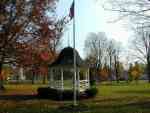
The gazebo was erected about 1880 and limestone walls were laid up on the banks of the narrow creek during 1897-99 by Robert Hughes, who was paid from funds raised through community entertainments.
A commemorative boulder was placed by the graduating classes of 1900 and 2000 and another by the Daughters of the American Revolution. On May 30, 1915, the latter dedicated their monument to the Revolutionary soldiers buried in
the vicinity. Both monuments continue to provide landscape features to the square.
Longtime residents of the patent may remember less solemn features of the square: the cow which Flossie Jones
tethered to a tree in the square and the World War I airplane which was parked for years in the sheds behind the
Presbyterian and Baptist churches.
Today the public square continues to hold a special place in the community as the site of high school graduations,
concerts, and the picnics and frisbee games of both travelers and residents. The village's pride in its lovely square
has prompted the formation of a group dedicated to maintaining and improving its appearance. The unique historical, architectural and visual character of the square has merited recognition and it was listed on the National Register of Historic Places in 1992.